 2004 Hurricane Season (2 mb)
2004 Hurricane Season: Global Satellite IR
Description:
The 2004 hurricane season started on July 31 with Hurricane Alex and continued all the way through to December 2 with Tropical Storm Otto. The season featured 15 tropical storms, 9 of which became hurricanes, and 6 of those were classified as major hurricanes. This over-active hurricane season tallied up a bill of $42 billion in damages, which at the time was record high. Florida took the brunt of the damage with 4 major hurricanes making landfall in the state. Two of the hurricanes, Frances and Jeanne, landed in almost the same location on the east coast of Florida only 3 weeks apart. It is estimated that one in every five homes in Florida was damaged in the 2004 hurricane season.
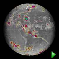
This data set was created using infrared satellites, which measure emitted heat. Where there are clouds, the satellites measure the heat emitted by the cloud rather than the ground below it. Because clouds are so much colder than the ground, they are easy to detect on IR satellite images. Areas that show up in the bright colors are extremely cold and the gray shades are areas that are warmer. The higher the cloud, the colder the cloud top will be and so it shows up vividly on the IR satellite image. Hurricanes and tropical storms are well developed weather systems and therefore have high clouds that are easy to detect in the IR satellite images.
Notable Features:
| Name | Date | Peak Strength | Landfall Location | Damage Cost |
| Alex | Jul 31-Aug 6 | Cat. 2 | Outer Banks, NC | N/A |
| Bonnie | Aug 2-4,9-12 | Trop. Storm | Florida Panhandle | N/A |
| Charley | Aug 9-15 | Cat. 4 | West Coast of Florida Coast of South Carolina |
$ 14 billion |
| Danielle | Aug 13-21 | Cat.2 | No landfall | N/A |
| Earl | Aug 13-16 | Trop. Storm | Windward Islands | N/A |
| Frances | Aug 24-Sep 6 | Cat. 4 | Sewall’s Point, FL St. Mark’s, FL |
$ 8 billion |
| Gaston | Aug 27-Sep 1 | Cat. 1 | Coast of South Carolina | N/A |
| Hermine | Aug 29-31 | Trop. Storm | No landfall as Trop. Storm | N/A |
| Ivan | Sep 2-16,22-24 | Cat. 5 | Gulf Shores, AL as cat. 3 | $ 13 billion |
| Jeanne | Sep 13-27 | Cat. 3 | Stuart, FL (close to Frances’s first landfall) | $ 6 billion |
| Karl | Sep 16-24 | Cat. 4 | No landfall | N/A |
| Lisa | Sep 19-Oct 3 | Cat. 1 | No landfall | N/A |
| Matthew | Oct 8-10 | Trop. Storm | Louisiana Coast | N/A |
| Nicole | Oct 10-11 | Trop. Storm | No landfall | N/A |
| Otto | Nov 30-Dec 2 | Trop. Storm | No landfall | N/A |
40 to -30°C Shades of gray
-30 to -40°C Yellow
-40 to -50°C Red
-50 to -60°C Pink
-60 to -70°C Turquoise
-70 to -80°C Green
-80 and lower Blue and Magenta
Data Category
Major: Atmosphere
Keywords:
Atmosphere, hurricane, IR satellite, satellite
| Data Set Name | 2004 Hurricane Season |
| Data Set Directory Name | 2004_ir_hurricane |
| Data Set Source | NOAA |
| Data Set Developer | NOAA |
| Visualization Developer | Mike Biere, NOAA/GSD |
| Audio | shared/sos/media/audio/CoupeStudios/Music/HurricaneLoop.mp3 |
| Download | FTP |