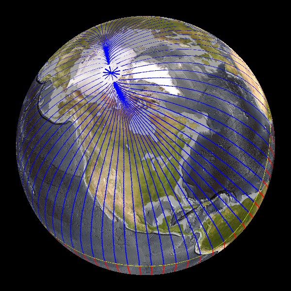
 Magnetic Lines with Earth Shaded background (9 mb)
Earth's Magnetism
Description:
Earth is like a giant magnet with a North and South Pole. However, the magnetic North and South Pole are not aligned with the Geographic North and South Pole. The Geographic North Pole is defined by the latitude 90° N and is the axis of the Earth's rotation. The Magnetic North Pole is where the Earth's magnetic field points vertically downward. The Earth creates its own magnetic field from the electric currents created in the liquid iron-nickel core. In order to illustrate the earth's magnetic field, three datasets for Earth's Magnetism have been created. All of these datasets show the changes in the magnetic field from 1590 - 2010. The first dataset shows the magnetic field lines at the surface of the Earth. The magnetic poles are indicated by stars. The blue lines show where the magnetic field dips into the Earth and the red lines show where the magnetic field emerges from the Earth. Where the field lines are horizontal to the Earth, between the red and blue lines, is the magnetic equator shaded yellow.
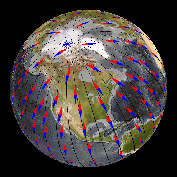 Magnets with Earth Shaded background (3 mb)
Compass needles point in the direction of the magnetic field lines, which is generally different from the direction to the Geographic North Pole. The compass pointing direction can also differ from the direction to the Magnetic North Pole since the magnetic field lines are not just circles connecting the magnetic poles. The second dataset shows the compass pointing directions around the world. The black lines (meridians) indicate the direction of True North. The angle between the compass pointing direction and True North is called magnetic declination. The third dataset shows lines of equal magnetic declination measured in degrees east (positive) or west (negative) of True North. The black line is where the declination equals zero and the direction of True North and Magnetic North are equal. The Magnetic North and South Poles are indicated by the black stars. It is important to know the magnetic declination when using a compass to navigate so that the direction of True North can be determined. Since the 1970's the movement of the Magnetic North Pole has accelerated, which is noticeable in all three datasets.
 Magnetic Declination with Earth Shaded background (9 mb)
More information on Earth's Magnetism can be found here.
Notable Features:
- The magnetic poles (indicated by stars) slowly move with time
- In the magnetic field lines dataset, the yellow line is the magnetic equator
- The pointing direction of the compass needles and the magnetic declination vary with time due to changes of the Earth's magnetic field
- Since the 1970's the Magnetic North Pole has accelerated from less than 10 to more than 30 miles per year
Data Category
Major: Land
Keywords:
Land, NGDC, magnetism, North Pole, True North, magnetic declination, magnetic field
In these figures and animations, the magnetic field from 1590 to 1980 is given by the GUFM-1 model of Jackson et al. (2000), while the field from 1980 to 2010 is given by the 10th generation of the International Geomagnetic Reference Field.
| Data Set Name | Magnetic Lines with Earth Shaded background |
| Data Set Directory Name | earths_magnetism/magnetic_lines |
| Data Set Source | NOAA National Geophysical Data Center |
| Data Set Developer | NOAA National Geophysical Data Center |
| Visualization Developer | Stefan Maus, NOAA NGDC |
| Audio | No |
| Contact | Stefan Maus, NOAA NGDC |
| Download | FTP |
| Data Set Name | Magnets with Earth Shaded background |
| Data Set Directory Name | earths_magnetism/magnets |
| Data Set Source | NOAA National Geophysical Data Center |
| Data Set Developer | NOAA National Geophysical Data Center |
| Visualization Developer | Stefan Maus, NOAA NGDC |
| Audio | No |
| Contact | Stefan Maus, NOAA NGDC |
| Download | FTP |
| Data Set Name | Magnetic Declination with Earth Shaded background |
| Data Set Directory Name | earths_magnetism/magnetic_declination |
| Data Set Source | NOAA National Geophysical Data Center |
| Data Set Developer | NOAA National Geophysical Data Center |
| Visualization Developer | Stefan Maus, NOAA NGDC |
| Audio | No |
| Contact | Stefan Maus, NOAA NGDC |
| Download | FTP |