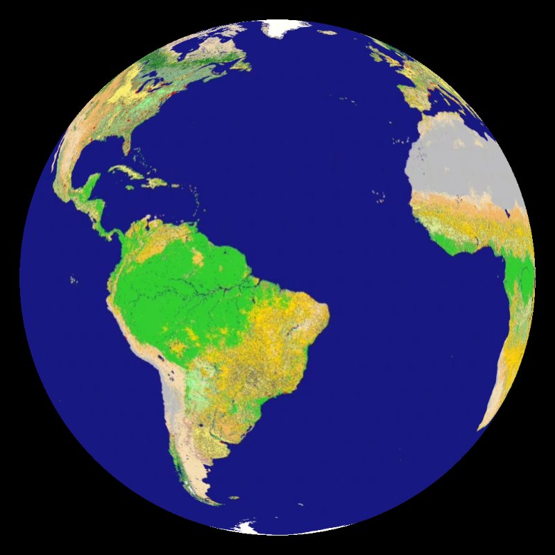
 Land Cover Animation (14 mb)
Global Land Cover
Description:
The Moderate Resolution Imaging Spectroradiometer (MODIS) instrument on NASA's Terra satellite provides scientists with a new view of the Earth. Using data collected by MODIS, researchers at Boston University were able to create these land cover maps. Understanding the land cover of Earth aids policy makers involved in natural resource management. The maps are also critical for scientists as they study changes in the Earth system and as they model the Earth system. For example, in order to calculate the carbon budget for the Earth system, scientists can use these maps to determine the extent of vegetation covering the land surface that is absorbing carbon dioxide. Each of the varying land types have different impacts on the Earth system. Snow and ice cover cool the planet by reflecting sunlight back to space, forests absorb huge amounts of carbon dioxide, and croplands and urban areas reflect the human impact on the Earth.
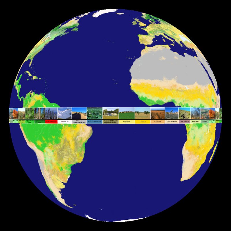 Land Cover Map with Ribbon of Labels (23 mb)
The data that was analyzed for this map was collected by MODIS from November 2000 through October 2001. This map is the most refined global picture ever created of the distribution of Earth's ecosystems and land use patterns. The spatial resolution of this land cover map is 1 kilometer (.6 miles), a noted improvement on older versions of similar maps. The map is color coded based on 16 different land cover types. The land cover types fall into one of two categories, natural vegetation and agricultural, urban, and barren. There are eleven natural vegetation land types, ranging from Evergreen Needleleaf Forests to Permanent Wetland. The remaining five land types vary from croplands to snow and ice to urban and built-up. There are three versions of this dataset. Two show the same map base map, but have different label styles. One shows all of the labels in a ribbon around the equator and the other has a slide show of each land type. The third version shows each of the categories separately then progressively overlays the layers.
|
|
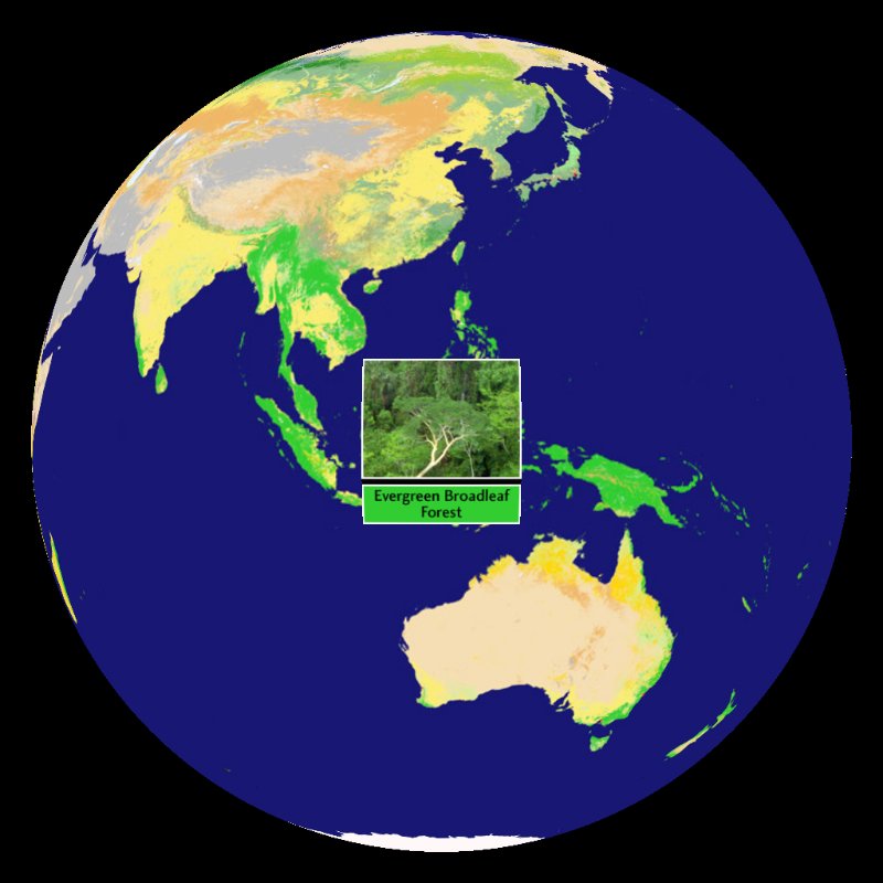 Land Cover Map with Slideshow of Labels (19 mb)
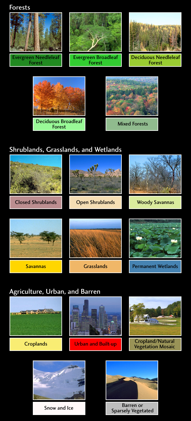 Click for larger view
For more information, visit: http://earthobservatory.nasa.gov/Newsroom/view.php?id=22585
Notable Features:
- There are 16 different land types used in this dataset
- The spatial resolution is 1 kilometer (.6 miles)
Data Category
Major: Land
Keywords:
Land, satellite, MODIS, cover, vegetation
| Data Set Name | Land Cover Animation |
| Data Set Directory Name | land_cover/animation |
| Data Set Source | NASA MODIS |
| Data Set Developer | Boston University |
| Visualization Developer | Boston University, NASA |
| Audio | No |
| Download | FTP |
| Date Added | April 2011 |
| Data Set Name | Land Cover Map with Ribbon of Labels |
| Data Set Directory Name | land_cover |
| Data Set Source | NASA MODIS |
| Data Set Developer | Boston University |
| Visualization Developer | Boston University, NASA |
| Audio | No |
| Download | FTP |
| Date Added | April 2011 |
| Data Set Name | Land Cover Map with Slideshow of Labels |
| Data Set Directory Name | land_cover |
| Data Set Source | NASA MODIS |
| Data Set Developer | Boston University |
| Visualization Developer | Boston University, NASA |
| Audio | No |
| Download | FTP |
| Date Added | April 2011 |