These paleo-graphic visualizations are commercial products and are therefore not available from NOAA nor are they included or distributed as part of the Science On a Sphere® system. These visualizations can be purchased from the contacts listed below.
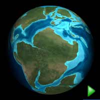 ARC Science Plate Tectonics and Paleo Animation (8 mb)
Plate Tectonics and Paleo Animation
Description:
There are two different animations that show the plate tectonics through history. The first is from the ARC Science Center. It is a time-elapsed frame set of approximately 4000 high-resolution images with original artwork visualizing the evolution of the Earth's surface due to plate tectonics over the past 600 million years. The second is from Prof. Chris Scotese, PALEOMAP Project. The PALEOMAP Drift animations show the motions of the continents and the evolution of the ocean basins from the late Precambrian (750 million years ago), through the assembly and breakup of Pangea (250 million years ago), and extends the modern plate motions +250 million years into the future (Pangea Ultima). The whole animation is approximately 8000 frames. Both datasets show the large southern landmass called Pannotia, which began to break apart into several small pieces as well as Gondwana 550 million years ago, which eventually became the cores of North America, Northern Europe, and Siberia. The smaller pieces from the break up of Pannotia drifted together to form Laurasia. Gondwana and Laurasia drifted for more than 200 million years, and then came back together again, pushing up a great mountain range of which the Appalachian Mountains are one remnant.
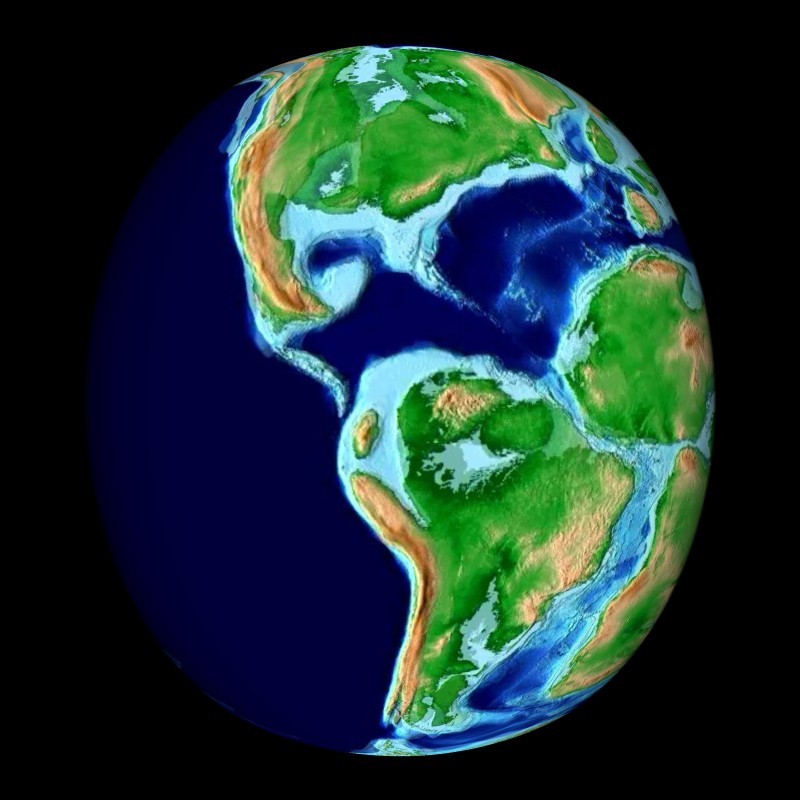 Christ Scotese Plate Tectonics and Paleo Animation (2 mb)
This new super continent, Pangaea, then began its break up around 300 million years ago into what became the present day world. During the Jurassic period, 140-180 million years ago, the North Atlantic opened up, followed by South America and Africa pulling apart to create the South Atlantic, and then the final break up of Gondwana into India, Australia, and Antarctica. When India broke free from other landmasses, it traveled with great speed toward current day Asia. The collision between the two land masses caused the Himalayas to form. Also during this time, several mass extinctions occurred due to various warming and cooling events.
The original 29 frames that were used to created that Arc Science Plate Tectonics Animation are available for public use from Dr. Ron Blakey.
Notable Features:
- Both the PALEOMAP and ARC Science animations can be customized to include a marker that travels with the continents indicating the location of a particular museum, city or state through time.
- Appearance of green shading signifying the presence of plant life
- Appalachian Mountains: oldest remnant mountain range to appear
- Pangaea: Major super continent that broke up 300 million years ago
- Break off of India which collides into Asia with great speed causing the formation of the Himalayas and Mount Everest
- Labels indicating the year and the geological period are available
Data Category
Major: Land, Models and Simulations
Keywords:
Land, Models and Simulations, paleontology, plate tectonics
| Data Set Name | Paleo Geographic |
| Data Set Directory Name | paleo/arc_science |
| Dats Set Source | Ron Blakey, Department of Geology, Northern Arizona University |
| Data Set Developer | ARC Science Simulations; Loveland, Colorado |
| Visualization Developer | ARC Science Simulations; Loveland, Colorado |
| Audio | /shared/sos/media/audio/CoupeStudios/Music/PlateTectonics.mp3 |
| Contact | Thomas Ligon, ARC Science Simulations, 970-667-1168 |
| Data Set Name | Scotese Paleo Drift |
| Data Set Directory Name | paleo/scotese |
| Dats Set Source | Prof. Christopher Scotese, PALEOMAP Project |
| Data Set Developer | Prof. Christopher Scotese, PALEOMAP Project |
| Visualization Developer | Prof. Christopher Scotese, PALEOMAP Project |
| Audio | no |
| Contact | Chris Scotese Paleomap Project, 817-275-1697 |
| Data Set Name | Paleo Geographic raw frames from Blakey |
| Data Set Directory Name | blakey_paleo |
| Dats Set Source | Ron Blakey, Department of Geology, Northern Arizona University |
| Data Set Developer | Ron Blakey, Department of Geology, Northern Arizona University |
| Visualization Developer | Ron Blakey, Department of Geology, Northern Arizona University |
| Audio | no |
| Contact | Ron Blakey, Department of Geology, Northern Arizona University |
| Download | FTP |