 Japan Tsunami Wave Heights, March 11, 2011 (13 mb)
Japan Earthquake and Tsunami Wave Heights,
March 11, 2011
Description:
On March 11, 2011 at 2:45 local time, a 9.0 magnitude earthquake occurred 81 miles (130 km) off the east coast of Sendai, Japan, triggering a massive tsunami. It is estimated that the initial tsunami wave took 10 to 30 minutes to make its first landfall. Forecasted wave heights were up to 33 ft (10 m) and there were many reports of tsunami waves three stories high in parts of Japan. Across the Pacific Ocean, many countries issued evacuations along the coasts because of the predicted tsunami waves.
 Japan Earthquake, March 11, 2011 (1 mb)
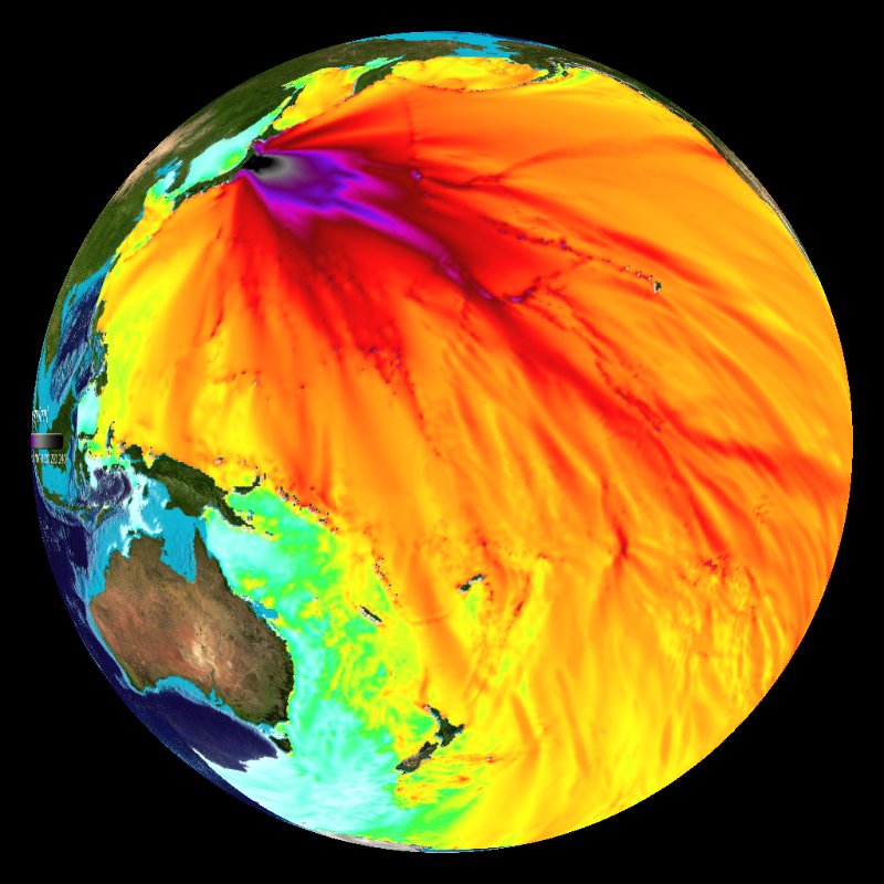
There are several datasets related to this event. The first is a model run of predicted tsunami wave heights from the Center for Tsunami Research at the NOAA Pacific Marine Environmental Laboratory. It shows the predicted wave heights of the tsunami as it travels across the Pacific basin. The largest wave heights are near the earthquake epicenter, off Japan. The wave decreases in height as it travels across the deep Pacific but grows taller as it encounters shallow waters near coastal areas. In general, the energy of the wave decreases with distance, causing the maximum height of the waves at the coasts to decrease. This explains why coastal Hawaii does not see the heights that were encountered in coastal Japan. Out in the open ocean, areas of low wave height correspond to deeper areas in the ocean.
To show the earthquake activity, a snapshot of the Real-Time Earthquake dataset has been archived. This loop, which is composed of hourly images, starts on February 19, 2011 and runs through March 24, 2011. Increased activity near Japan can be seen in the days before March 11. After the event, hundreds of powerful aftershocks, occurred for days. Over thirty of the aftershocks had a magnitude of greater than 6. In addition, a third dataset has been created by merging the earthquake activity with the predicted tsunami wave heights.
 Japan Earthquake and Tsunami Wave Heights Merged, March 11, 2011 (13 mb)
Notable Features:
- The earthquake had a magnitude of 9.0 and was followed by over thirty aftershocks with a magnitude of over 6.0
- The predicted wave heights are the height of the waves in the open ocean
Data Category
Major: Ocean, Land
Keywords:
Ocean, Tsunami, PMEL, Japan, Earthquake
| Data Set Name | Japan Tsunami Wave Heights, March 11, 2011 |
| Data Set Directory Name | oceans/japan_tsunami |
| Data Set Source | NOAA Pacific Tsunami Warning Center |
| Data Set Developer | NOAA Pacific Tsunami Warning Center |
| Visualization Developer | NOAA Environmental Visualization Lab |
| Audio | No |
| Download | FTP |
| Date Added | March 2011 |
| Data Set Name | Japan Earthquake, March 11, 2011 |
| Data Set Directory Name | land/japan_quake |
| Data Set Source | United States Geological Survey |
| Data Set Developer | Steve Albers, NOAA/GSD |
| Visualization Developer | Steve Albers, NOAA/GSD |
| Audio | No |
| Download | FTP |
| Date Added | March 2011 |
| Data Set Name | Japan Earthquake and Tsunami Wave Heights Merged, March 11, 2011 |
| Data Set Directory Name | land/japan_quake/with_tsunami |
| Data Set Source | United States Geological Survey |
| Data Set Developer | NASA GSFC |
| Visualization Developer | Steve Albers, NOAA/GSD, NASA GSFC |
| Audio | No |
| Download | FTP |
| Date Added | March 2011 |