 Red Mars (5 mb)
Mars —The Red Planet
Description:
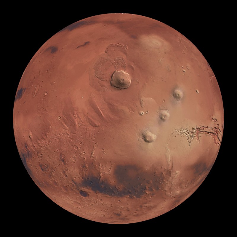
Mars is aptly referred to as the red planet as its surface is red due to a high concentration of iron oxides in the soil. Often the center of science fiction stories, Mars once was believed to support intelligent creatures. Missions to Mars in 1965 and again in 1976 proved that there were no living organisms on Mars. However, this small rocky planet, the fourth from the sun, does have polar ice caps that change in size with the seasons. It is believed that 3.5 billion years ago the most significant floods in the solar system took place on Mars. The Mars Odyssey found large amounts of ice about 1 meter below the surface of Mars in 2002. This ice, thought to be from the floods, would fill Lake Michigan over two times. This is still not enough water to explain the erosion visible on Mars.
 Mars Magnetic Map 8/2005 (15 mb)
Mars touts not only the highest point in the solar system, but also a canyon over 4 miles (6.5 km) deep. The highest point, the mountain Olympus Mons is 88,500 feet (almost 17 miles) above the surrounding area and has an astounding diameter of over 300 miles. The base of the mountain is surrounded by a cliff that drops 20,000 feet (almost 4 miles). Compared to Mount Everest, the tallest point on Earth at 29,035 feet, Olympus Mons is over three times taller. Another spectacle on Earth is the Grand Canyon which is 277 miles long and 6000 feet deep at its deepest point. On Mars, Valles Marineris is almost 2500 miles long, approximately the width of the United States, and nearly 4 miles (6.5 km) deep. In addition to the surface of Mars dataset, there is a dataset that includes images of the rovers that landed on Mars and the pictures that they took. Also in the Mars collection of datasets is an illuminated Mars, with day and night sides shown on the sphere. ( description of Illuminated Mars) Another dataset for Mars shows the crustal magnetic fields of Mars as measured by the Mars Global Surveyor. This is an important map because it proves that one point Mars had plate tectonics. Red is used for positive magnetic fields and blue is negative fields.
 Illuminated Mars
Notable Features:Mars
- Olympus Mons: highest point in the solar system at 88,500ft
- Valles Marineris: Canyon 2500 miles long and 4 miles deep
- Hellas Planitia: an impact crater in the Southern Hemisphere 4.3 miles deep and 1400 miles in diameter
- Presence of ice caps
Notable Features:Magnetic Map
- Magnetic fields provide proof of plate tectonics on Mars
- Red: Positive magnetic fields, blue: negative magnetic fields
Data Category
Major: Astronomy
Minor: Mars
Keywords:
Solar System, planet, red, magnetic map
| Data Set Name | Red Mars ( 25 degree tilt) |
| Data Set Directory Name | mars/original |
| Data Set Source | NASA explorations mission |
| Data Set Developer | NASA |
| Visualization Developer | David Himes, NOAA/GSD |
| Audio | No |
| Download | FTP |
| Google Earth | KML file |
| Data Set Name | Mars Landing Sites with Pictures |
| Data Set Directory Name | mars/landings |
| Data Set Source | Mars explorations missions |
| Data Set Developer | NASA Goddard Space Flight Center |
| Visualization Developer | NASA Goddard Space Flight Center |
| Audio | No |
| Contact | NASA Goddard Space Flight Center |
| Download | FTP |
| Data Set Name | Mars Magnetic Map 8/2005 |
| Data Set Directory Name | mars/magnetic |
| Data Set Source | Mars Global Surveyor |
| Data Set Developer | Dr. Jack Connerney, NASA Goddard Space Flight Center |
| Visualization Developer | NASA Goddard Space Flight Center |
| Audio | No |
| Contact | NASA Goddard Space Flight Center |
| Download | FTP |