 All Satellites (6 mb)
Geostationary Satellite Positions and Polar Orbiting Satellite Tracks
Description:
Satellites are a key tool for scientists to monitor and observe the Earth's atmosphere from space. Geostationary satellites orbit around the Earth at the same rate as the Earth rotates so that the satellites are over the same spot on Earth all the time. This allows them to collect a continuous stream of data for one location so that "movies" of the data can be made. The satellites are positioned 22,300 miles above the Earth's surface in order to view the Earth's full disk and to maintain their geostationary orbit. Geostationary satellites travel at about 7000mph in order to maintain their geostationary orbit. In addition to geostationary satellites, scientists also use polar orbiting satellites. These satellites circle the Earth, crossing the poles on each orbit. Typically, polar orbiting satellites are about 500 miles above the Earth's surface. The satellites travel at almost 17,000mph, allowing them to orbit the Earth in roughly 100 minutes. A polar orbiting satellite is able to cover the whole Earth in less than one day.
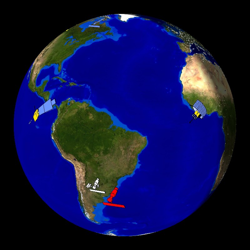
There are hundreds of scientific satellites orbiting the Earth. This dataset shows the positions of seven geostationary satellites and the tracks of several polar orbiting satellites, plus the location of the International Space Station over one day, February 15, 2007. The day/night terminator is also included in this dataset. Each of the polar orbiting satellites travel at slightly different heights, allowing them to pass by one another without crashing.
Notable Features:
- Geostationary Satellites
- NOAA's GOES-West - 135° West
- NOAA's GOES-East - 75° West
- EUMETSAT's Meteosat-9 - 0°
- EUMETSAT's Meteosat-7 - 57° East
- ISRO's INSAT-3C - 74° East
- CMA's FY2C - 105° East
- JMA's MTSAT-1R - 140° East
- Polar Orbiting Satellites
- Blue - NOAA-17 and NOAA-18
- Yellow - Defense Meteorological Satellite Program
- Red - NASA, large ones are Terra and Aqua, small one is TRMM (notice the different orbit type)
- White - International Space Station
Data Category
Major:Atmosphere
Keywords:
NOAA, GOES, EUMETSAT, JMA, geostationary, polar orbiting, satellites, International Space Station
| Data Set Name | All Satellites |
| Data Set Directory Name | all_sats |
| Data Set Source | Rick Kohrs, SSEC, Space, Science, and Engineering Center |
| Data Set Developer | Rick Kohrs, SSEC, Space, Science, and Engineering Center |
| Visualization Developer | Rick Kohrs, SSEC, Space, Science, and Engineering Center |
| Audio | Yes |
| Contact | Rick Kohrs, SSEC, Space, Science, and Engineering Center |
| Download | FTP |
| Google Earth | KML file |